Archive for the ‘Mapsicle’ Category

Thinking about Mapsicle

Sunday, November 22nd, 2009

Just seen this blog post about Augmented Reality – a new interface to search, explore and discover.

The blog post has capture the essence of the potential in Mapsicle.

http://www.rocketcontest.org/faqs.cfm

State of the art augmented reality apps enable you to check out what’s around your current position and put it in context of what you can see in a certain direction – soon we’ll find out what’s around the corner in the same photorealistic way – but without having to walk there if it is not worth it.

Thinking about Mapsicle…

We can virtually explore and use augmented virtual reality as an intuitive real world metaphor for search, exploration and discovery.

Mapsicle can be used to make a number of interactive applications to virtually explore locations. What about an streetview driven kiosk to explore a theme park like Legoland or Disneyland.

We’re entering a new age of mashups powered by streetview based applications.

Hire us to build your Streetview Applications

Wednesday, November 18th, 2009

Mapsicle - All Locations_1258497567039
disneyland


Want to view your GIS / data layers on Streetview? Talk to us at ProjectX.

Using the library Mapsicle you can create a whole new world of applications using Google maps streetview.

  • Advanced Store locators: Create store locators that show exactly how to get to your store from the user’s current location.
  • Interactive tours: Combine Street View with content to give tours of the streets of the world.
  • Digital signage: Create interactive advertising on Street View using video and images.
  • Interactive kiosk: Build a touch screen information kiosk for visitors.
  • Games: Build a treasure hunt application or a racing game to drive around Thunderhill raceway

We know how to connect your GIS with Streetview. Whether you have store locations, assets or want to put your companies branding on Streetview, we can help!

We’re looking for clients, who want to make some innovative mashups or want to view their assets using Streetview.

Contact John, if you’re interested in connecting streetview with your data!

Beyond Mapsicle 1.0 – we need your help

Wednesday, November 18th, 2009

Mapsicle 1.0 is live and we’re already thinking about how to make it even better. Its opensource, so we are looking to what features developers want as they look to use it to build applications.

Here is a list of enhancements we’ve been thinking about:

  • Reverse Geocoder for Mapsicle – We want to be able to “click anywhere” on Streetview and return the relative position in 2d space where that point is a lat long. This functionality would help developers to enable users to click on streetview as an easy way to add content.
    This presents a number of challenges as its difficult to be able to translate the depth of the field of view relative to the current position. Is where you are clicking in the next block or across a field or far away from your content location?

    Its hard to calculate – You could use a vector/line pointing out from the location intersecting where you clicked on the map and then geocode along that line to find a set of lat / longs to estimate the location you are looking for. Also you could use the a normal map to triangulate position in 2d space. Or could the streetview navigation polygon help to determine the lat long / position on the surface of the building?

  • Polygons and Polylines – We need to add polygons and polylines to Mapsicle. Imagine being able to create a polygon to match the shape of a building or outline a floor of a building. You would need to be able to click on the polygons like selecting a floor on a building.

    If we create polygons and align them to the surface of a building then we can transform images and create virtual billboards.

  • Height – What’s the height of a position relative to the ground. This would allow applications to figure out the height of a point on a building.
  • Advanced Info-windows – Integrate the advanced info windows as seen in the native google maps API into streetview.

We need you help, we’d love your involvement in making Mapsicle and streetview applications even better.

Introducing Mapsicle – a Street View library

Tuesday, November 17th, 2009

Ever since Street View came out in New Zealand, we’ve been itching to play around with StreetView. As part of our Summer of Code project, Stephen built Street View prototype called Mapsicle. Since then Mapsicle became a pet R&D project at ProjectX.

Today, we’d like to announce the V1 release of Mapsicle as part of the Gmaps-util library.

What can you do with Mapsicle?

Using Mapsicle library, you can do a lot of interesting things:
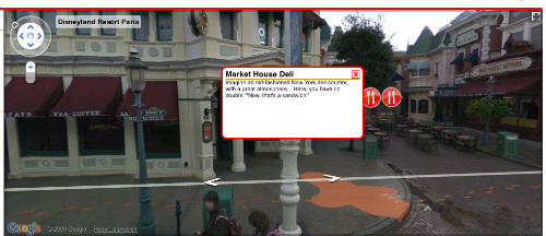
disneyland

  • Create and show markers at various locations on Street View like at Disneyland Paris
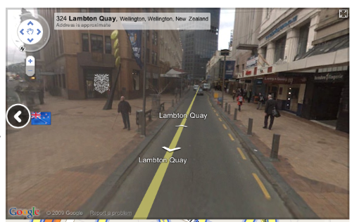
mapsicle_icons

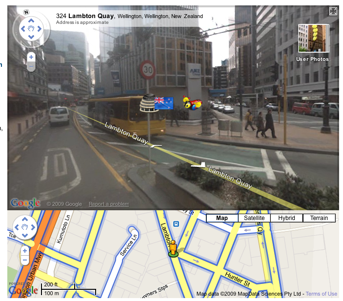
  • Show markers that are outside of the field of view like the NZ flag marker above.
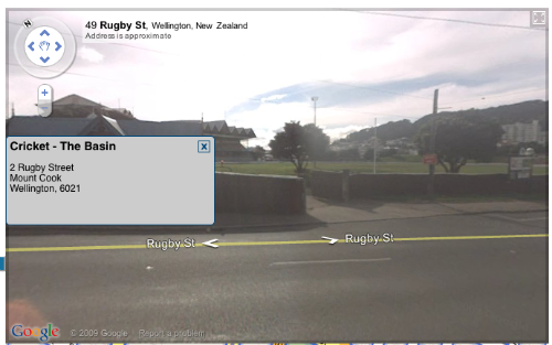
info_window

  • Create info-windows at locations.

Getting started

Getting started on Mapiscle is really easy. To add Mapsicle to any page simply:

  1. Download the library from SVN for Gmaps-utils library .
  2. Include the mapsicle.js in the document header
  3. <script src="mapsicle.js" type="text/javascript"></script>
  4. Define a ‘div’ element on your page to contain the Mapsicle object
  5. <div id="mapsicle_div" style="width:600px;height:400px;"></div>
  6. On the page load event, create a new Mapsicle object, with the first param being the id of the container ‘div’ element,
    and the second being the init a GLatLng object for the inital location.
  7. function init(){
        var mapsicle = new Mapsicle("mapsicle_div", new GLatLng(-41.292579, 174.779075));
    }

Simple Example

This example shows the basics of adding a marker and location to the Mapsicle view.

<!DOCTYPE html PUBLIC "-//W3C//DTD XHTML 1.0 Transitional//EN" "http://www.w3.org/TR/xhtml1/DTD/xhtml1-transitional.dtd">
<html xmlns="http://www.w3.org/1999/xhtml" xml:lang="en" lang="en">
    <head>

        <meta http-equiv="content-type" content="text/html;charset=UTF-8" />
        <title>Mapsicle</title>
        <script type="text/javascript" src="http://www.google.com/jsapi?key=YOUR_API_KEY"></script>

        <script type="text/javascript">
            google.load("maps","2");
        </script>
        <script type="text/javascript" src="mapsicle.js"></script>

        <script type="text/javascript">
            function init(){
                var mapsicle = new Mapsicle("mapsicle_div", new GLatLng(-41.292579, 174.779075));
                var marker =  new SVMarker({
                    showOffscreen:true,
                    iconURL:"images/mapsicle_marker.png",
                    width:150,
                    height:150,
                    scale:0.2
                });
                var location = new SVLocation({
                    lat:-41.29249,
                    lng:174.778889,
                    marker:marker
                });
                mapsicle.addLocation(location);
            }
        </script>
    </head>
    <body onload="init();" onunload="GUnload()">

        <div id="mapsicle_div" style="width:850px;height:400px;"></div>
    </body>
</html>

View example (simple_demo.html).

Mapiscle possibilities

We believe there are loads of possibilities in the types of mashups and map applications that you can now create with Mapsicle. Add to that  to the Street View partner program, and Mapsicle will help to launch a new generation of mashups.

Here are some ideas :

  • Annotate locations – Need to annonate a building or a place now you can like or demo – StreetTag.net
  • Advanced Store locators – Create store locators showing you exactly how to get to your store from their current location.
  • Interactive tours – Combine Street View with content to show people interactive tours of the streets of the world.
  • Interative kiosk – What about Street View as a touch screen information kiosk.
  • Digital signage – Create interactive advertising on Street View using video and images.
  • Games – Build a treasure hunt application or what a game to drive around Thunderhill raceway ?
  • Mashups – How about adding Street View to your mashup ?

Contribute

It is early days for the library, and we have a bunch of features that we are working enhance what you can do with Street View. You can contribute and enhance Street View as part of the Google Maps Utility library. We’d really love your feedback to help us improve Mapsicle and build more cool apps for the Google maps platform.

http://www.canakkaleruhu.org http://www.vergimevzuati.org http://www.finansaldenetci.com http://www.securityweb.org http://www.siyamiozkan.org http://www.fatmaozkan.com http://www.sgk.biz.tr http://www.denetci.gen.tr http://www.bagimsizdenetim.biz.tr http://www.mevzuat.biz.tr http://www.security.biz.tr http://www.sorgulatr.com http://www.kanunlar.biz http://www.prsorgu.net http://www.sirabul.com http://www.emekliol.org http://www.coklupagerank.com http://www.coklupagerank.net http://www.coklupagerank.org http://www.prsorgu.org http://www.scriptencode.com http://www.sirabul.net http://www.sirabul.org http://www.sitenizanaliz.com http://www.seoisko.com http://www.seomavi.com http://www.scriptencode.net http://www.scriptencode.org