The Wellington Inner City Bypass, in all its (ahem) glory, is now properly represented on ZoomIn and Smaps. We’re working on our regular update of all the map tiles for New Zealand, but we figured that a major change to the State Highway system, that also reorganised the one-way system in an urban area, was worth getting right straight away.
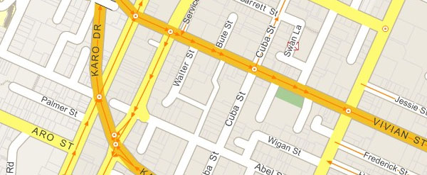
We thought we’d taken much longer than we would have liked to get this done, but since changes to the one-way network on the surrounding roads kept on happening right until a couple of weeks ago, we thought it was best to get all the changes done in one go. As it turns out, it looks like we’re the first major mapping system to show the bypass: Google, Multimap, Microsoft and Yellow Maps all still have the old configuration. I can understand why it’s taking them a while: it turns out that we had to do a lot of manual editing of the streets data, and our local knowledge came in handy.
While Karo Drive is now visible on the maps, we haven’t updated our addresses database yet, so you can’t search for it. That shouldn’t be a great hardship, since at the moment there seem to be no actual addresses on Karo Drive (Martha’s Pantry is the only business there, and its address is on Cuba St), and the relocated heritage buildings there and on the adjacent Tonks Grove will remain empty for a year or more. Some would argue that Karo Drive doesn’t deserve to be listed as a “place”, since it’s a means of getting between places rather than somewhere to be, but I couldn’t possibly comment! In any case, we’ll be including Karo Drive and Tonks Grove along with all the other street changes nationwide in our next database update.


 <center>
 </center>
 </center>
 </center>